
Thaba-Tseka · Getting around
How to get around Thaba-Tseka and travel from the airport
August 29, 2026 · last updated · about 3 min read
Getting Around Thaba-Tseka
Thaba-Tseka is a compact highland center. Within the town, walking is the most practical way to navigate between administrative offices, clinics, and shops. For rural travel outside town, shared minibus taxis run along the paved A3 corridor, while pickup trucks handle unpaved mountain tracks. Neither uses fixed schedules; vehicles depart when full.
Fares and Ticketing
Transit passes and digital tickets do not exist. All fares are paid in cash directly to the driver or conductor. Carry small notes of Lesotho Loti or South African Rand, as change for large denominations is rarely available.
From Moshoeshoe I Airport (MSU)
Moshoeshoe I International Airport lies near Mazenod, over 200 kilometers west across high mountain passes:
- Rented 4WD: High cost band, moderate effort. Takes four to six hours. A high-clearance vehicle is recommended for navigating mountain passes.
- Private Transfer: High cost band, low effort. Pre-arranged drivers from Maseru provide direct transport without driving stress.
- Public Minibus: Low cost band, high effort. Requires a local taxi into Maseru's bus rank, then an eastbound minibus. Expect an all-day journey dictated by passenger fill times.
Practical Considerations
- Service Hours: Cross-district vehicles stop running by early afternoon. Avoid nighttime travel due to unlit mountain roads and livestock.
- Luggage: Minibuses have negligible cargo space; bulky items often require paying for an extra passenger seat.
- Accessibility: Unpaved, steep tracks and high-clearance vehicles offer no step-free accessibility for travelers with limited mobility.
Pick your dates — we'll search Thaba-Tseka hotels for you
Choose dates and guests, and the buttons below will open search results with your criteria. Prices differ between sites, so compare before you book.
 View on Booking.com
 View on Hotels.com
Things to see in Thaba-Tseka
See all →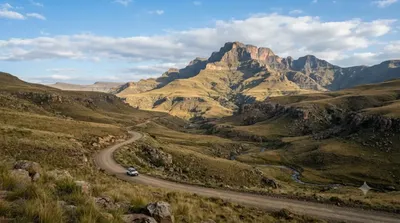
Nature
Thaba Putsoa
This mountain rises about 70km southeast of Maseru, along the route to Mohale Dam. At 3,096 meters, it is also the source of the Orange River.
Nature
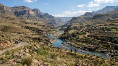
Malibamat'so River
The Malibamat'so River flows through northern Lesotho, rising on the eastern slopes of the Maloti Mountains and running south past the village of Lejone before joining the Senqu River. Along the way it offers scenic views as it cuts through the high mountain terrain.
More Thaba-Tseka guides
Best value
Where to stay in Thaba-Tseka for the best value
5-star & luxury
Where to stay for a luxury retreat in Thaba-Tseka
Pool villas & resorts
Where to stay for resort lodges and chalets with pools in Thaba-Tseka
Family travel
Where to stay in Thaba-Tseka for a family trip
Couples & honeymoon
Where to stay in Thaba-Tseka for a couples trip or honeymoon
Central & near stations
Where to Stay in Thaba-Tseka for Easy Access to Central Transport
Best time to visit
When Is the Best Time to Visit Thaba-Tseka, Lesotho?
First-time guide
How to visit Thaba-Tseka for the first time: arrival, layout, and travel tips
Getting around guides for other destinations
Guantánamo
How to Get Around Guantánamo and Travel from Antonio Maceo Airport
Cetinje
How to Get Around Cetinje and Travel from Podgorica Airport
North Nicosia
How to get around North Nicosia and travel from Larnaca Airport
Cienfuegos
How to get around Cienfuegos: transport options and airport transfers