
Thaba-Tseka · First-time guide
How to visit Thaba-Tseka for the first time: arrival, layout, and travel tips
August 29, 2026 · last updated · about 3 min read
Understanding the Town Layout
Thaba-Tseka functions as an administrative highland center rather than a sprawling city. The settlement is organized along the A3 road, which forms its central axis. The civic and commercial core lines this paved road, grouping government offices, supply stores, and fuel points. Surrounding this central corridor are residential homesteads and open pastures that blend into the surrounding hills.
Arriving from the Airport and Getting Around
From Moshoeshoe I International Airport (MSU) south of Maseru, traveling to Thaba-Tseka requires an overland mountain drive eastward via the A3 corridor. Minibuses run from Maseru, but a high-clearance vehicle or four-wheel drive is strongly advised for steep grades and varying road conditions. Within the town core, getting around on foot is easy. To reach surrounding valleys and trailheads, visitors rely on shared rural bakkies or hired 4WD transport.
What First-Timers Get Wrong
- Underestimating travel time: Mountain passes make the overland trip slow. Avoid driving after dark due to livestock and unlit mountain curves.
- Expecting digital payments: Card machines and ATMs are unreliable here. Stock up on cash before leaving Maseru.
- Ignoring weather swings: High altitude brings sudden cold snaps and heavy rains. Carry warm windproof layers even in warmer months.
Sensible Shape for a First Trip
Arrive in daylight, settle near the central road, and secure essential supplies. Spend your first full day exploring the town spine and taking short day walks along nearby ridges. Leave extended treks or trips to remote highland dams and passes for later once your transport and local conditions are confirmed.
Pick your dates — we'll search Thaba-Tseka hotels for you
Choose dates and guests, and the buttons below will open search results with your criteria. Prices differ between sites, so compare before you book.
 View on Booking.com
 View on Hotels.com
Things to see in Thaba-Tseka
See all →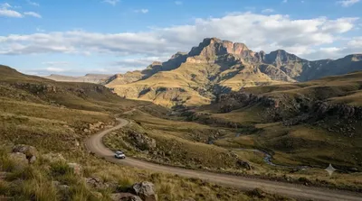
Nature
Thaba Putsoa
This mountain rises about 70km southeast of Maseru, along the route to Mohale Dam. At 3,096 meters, it is also the source of the Orange River.
Nature
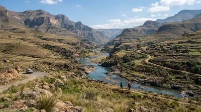
Malibamat'so River
The Malibamat'so River flows through northern Lesotho, rising on the eastern slopes of the Maloti Mountains and running south past the village of Lejone before joining the Senqu River. Along the way it offers scenic views as it cuts through the high mountain terrain.
More Thaba-Tseka guides
Best value
Where to stay in Thaba-Tseka for the best value
5-star & luxury
Where to stay for a luxury retreat in Thaba-Tseka
Pool villas & resorts
Where to stay for resort lodges and chalets with pools in Thaba-Tseka
Family travel
Where to stay in Thaba-Tseka for a family trip
Couples & honeymoon
Where to stay in Thaba-Tseka for a couples trip or honeymoon
Central & near stations
Where to Stay in Thaba-Tseka for Easy Access to Central Transport
Best time to visit
When Is the Best Time to Visit Thaba-Tseka, Lesotho?
Getting around
How to get around Thaba-Tseka and travel from the airport
First-time guide guides for other destinations
Guantánamo
First-Timer Guide to Guantánamo, Cuba: Layout, Transport, and Practical Tips
Cetinje
How to Plan Your First Trip to Cetinje: Layout, Transport, and Key Sights
North Nicosia
First-timer's guide to visiting North Nicosia: borders, layout, and transit
Cienfuegos
First-Timer Guide to Cienfuegos: Layout, Transport, and Practical Tips